zur deutschen Version, Flagge klicken oder tippen

- Federation of Saint Kitts and Nevis
- parliamentary monarchy with the British monarch as chief of state
- own name: Federation of Saint Kitts and Nevis
• Flags
• Historical Flags
• Meaning/Origin of the Flag
• Coat of Arms
• Meaning/Origin of the Coat of Arms
• Map
• Numbers and Facts
• History
• Origin of the Country's Name
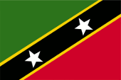
since 1983,
National and merchant flag,
ratio = 2:3,
Source, by: Flags of all Nations


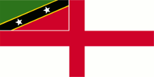
since 1983,
Naval flag,
ratio = 1:2,
Source, by: Flags of all Nations

since 1983,
Flag of the Governor General,
ratio = 1:2,
Source, by: Flags of the World
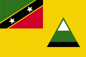
Flag of Nevis,
ratio = 2:3,
Source, by: Flags of all Nations

16./17th century,
The islands belong to the Spanish sphere of influence,
Source, by: Wikipedia (EN)

1620–1649,
Flag of the Commonwealth of England, Scotland and Ireland,
Source, by: Die Welt der Flaggen
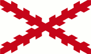
1625–1690,
Flag of France,
Source, by: Sodacan [CC BY-SA 3.0], via Wikimedia Commons
1660–1707,
Flag of the Commonwealth of England, Scotland and Ireland,
Source: Die Welt der Flaggen
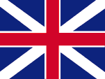
1707–1801,
Flag of United Kingdom,
Source, by:
Die Welt der Flaggen
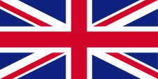
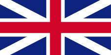
1801–1967,
Union Flag → quasi national flag,
Flag of United Kingdom,
ratio = 1:2,
Source, by: Wikipedia (EN)
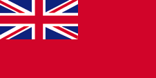
1864–1967,
Merchant flag,
ratio = 1:2,
Source, by: Flags of all Nations
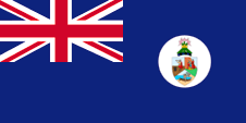
1958–1967, St. Kitts/Nevis & Anguilla,
Flag of the government (state flag),
ratio = 1:2,
Source, by: Flags of the World
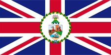
1958–1967, St. Kitts/Nevis & Anguilla,
Flag of the Governor,
ratio = 1:2,
Source, by:
Flags of the World
1967–1983, St. Kitts/Nevis & Anguilla,
National and merchant flag,
ratio = 1:2,
Source, by: Flags of the World
1967–1983, St. Kitts/Nevis & Anguilla,
Flag of the Governor,
ratio = 1:2,
Source, by: Flags of the World
Leeward Islands:
1871–1958,
Flag of the government (state flag),
ratio = 1:2,
Source, by: Flags of the World
1874–1959,
Flag of the Governor,
ratio = 1:2,
Quelle, nach: Wikipedia (EN)
Federation of the West Indies (1958–1962):
Flag of the Federation of the West Indies,
ratio = 1:2,
Source, by: Flags of the World
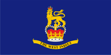
Flag of the Governor General,
ratio = 1:2,
Source, by:
Flags of the World
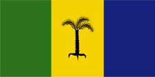
The current flag of St. Kitts and Nevis was designed by Edrice Lewis and was
introduced on 19th of September in 1983 on the occasion of independence. It
shows a diagonal, yellow-fringed, black stripe with two white five-pointed
stars, a green field at the top left and a red field at the bottom right. The
black stands for the African roots of most of the country's inhabitants, yellow
for the sun and green for the country's fertility. Red symbolises the blood that
was shed in the struggle for independence. The white stars symbolise the two
islands. They also symbolise the hope for freedom and peace. As the country
follows the British ensign and colour system, the colours of the flag will
correspond to the spectrum specified by the British Ministry of Defence in its
publication "Flags of all Nations" (a service regulation) for the following
colours: Green = pt 364 c, Red = pt 186 c, Deep yellow = pt 116 c. St. Kitts and
Nevis follows the British Ensign system to this day. This points to the links
with United Kingdom, as the naval flag is a White Ensign, a white flag with a
continuous red St George's Cross and with the national flag in the upper corner.
Initially, the islands, especially St. Kitts (St. Christopher), were
disputed between France and England/United Kingdom. In the Treaty of Utrecht in
1713, United Kingdom was officially granted St. Kitts, so that from that year
onwards the flag of the United Kingdom flew unchallenged over the islands. From
this point onwards, individuals, citizens and also the authorities represented
their status as citizens or organs of the British nation, embodied in the United
Kingdom, through the use of the Union Jack, then called the "Union Flag". At
sea, the British merchant flag, the Red Ensign, was intended for British
citizens from 1864. In a few cases, the citizens of a colony were authorised by
the Admiralty to use their own Red Ensign with the colony's badge at sea. The
Union Jack in the top corner of these flags signalled the connections to United
Kingdom.
United Kingdom introduced a flag system in 1864 in which:
•
war ships fly the "White Ensign" (naval flag), a white flag often with an
uninterrupted red St. George's-Cross and with the Union Jack in the upper staff
quadrant of the flag,
• merchant ships fly a "Red Ensign" (also named "Civil
Ensign" → civil flag, the real merchant flag), a red flag with the Union Jack in
the upper staff quadrant of the flag, and
• governmental ships fly the "Blue
Ensign" (flag for the use by the gouvernment → the actual state flag), a blue
flag with the Union Jack in the upper staff quadrant of the flag.
From
1865, the ships of the colonial governments were allowed to use a Blue Ensign
with a badge at the flying end. The respective governments were to provide
appropriate badges. Merchant ships and seafaring privateers from colonies were
only allowed to use a Red Ensign with a badge if the British Admiralty had
issued a corresponding licence for that colony.
Such a badge was often a
regional landscape depiction on a disc, often showed ships, historical events or
could simply be a kind of logo. Very often a badge also contained the name of
the country or a motto. However, some possessions had a coat of arms from the
beginning or were given their own coat of arms over the years and the badge was
abolished. To ensure a largely uniform appearance in the flying end of the
flags, coats of arms and other symbols were displayed on a white disc in the
size of the former badges.
However, there were also exceptions, as some
colonies dispensed with this white disc and placed their coat of arms or even
just the shield – sometimes enlarged – directly on the bunting. As early as the
1940s, the white disc was removed and the coat of arms was applied directly or
enlarged. This conversion process took place gradually, nowhere simultaneously
and completely. In some British possessions flags with the white disc are still
in use today, in others no longer and in some areas both variants exist side by
side.
From 1832 to 1958, the area was – from 1882 together with Anguilla
– part of the British colony of the Leeward Islands, a federal colony consisting
of individual sub-areas, sub-colonies or islands. These individual colonies had
their own flags, also called "Blue Ensigns" with their own badge, for use by the
governments of these colonies. The overarching political entity of the British
Leeward Islands also had its own Blue Ensign with its own Leeward Islands badge.
This badge was created in 1871 and showed a pineapple on a coastline with two
ships. The governor also used it on his flag. He was represented locally, in the
associated sub-territory, sub-colony or island, by an administrator. The federal
colony ceased to exist when it was incorporated into the Federation of the West
Indies, led by a Governor-General. Locally, in the associated sub-territory,
sub-colony or island, the highest representative of the Crown retained his rank.
He remained an administrator or even governor. The local flags (e.g. blue or red
ensigns, i.e. separate state or merchant flags) have been retained.
St.
Christopher (St. Kitts), Nevis and Anguilla had already been administratively
united into one colony within the colony of the Leeward Islands in 1882: Colony
of St. Christopher (St. Kitts), Nevis and Anguilla. The individual islands
probably already had their own seals in use, the images of which were combined
on one escutcheon in 1958 when the colony of the Leeward Islands was dissolved
and the colony of St. Christopher (St. Kitts), Nevis and Anguilla was allowed to
use its own state emblems. This escutcheon became the colony's badge on a white
disc, which was used on a "Blue Ensign". The shield was divided into three parts
and showed the heraldic images of the individual islands: Columbus with a
telescope on board of a ship (St. Kitts), three virgins at a spring (Nevis) and
a native with his boat on a coast (Anguilla).
From 1958 to 1962 the
territory was also – together with Anguilla – part of the British colony
"Federation of the West Indies". This political project was an attempt to unify
the administration and to create a state modelled on Canada, but also to
counteract the independence efforts of the associated islands and colonies.
However, jealousies arose between the large and small islands and even led to
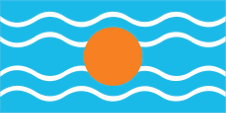
open dispute. The flag of the "Federation of the West Indies" was a light blue
flag with four horizontal white wavy lines and a golden disc in the middle. It
symbolized the sun over the Caribbean Sea. There is some doubt about the color
of the blue; it is often assumed to be the usual British heraldry blue. However,
a contemporary description calls it an "imperial blue" which would be light blue
and many contemporary prints also show this light blue.
On 27th of
February in 1967, internal self-government was granted by United Kingdom, and
St. Kitts, Nevis and Anguilla became an autonomous state associated with United
Kingdom. In this context, a new flag was introduced. This flag showed three
vertical stripes in green, yellow and blue, and in the centre of the yellow
stripe a black palm tree with three branches (St. Kitts, Nevis and Anguilla).
Flags with the same colours were and are also used in Grenada and in St.
Vincent. The current flag was introduced at independence on 19th of September in
1983.
The idea of secession immediately came to life in Anguilla, which
was consistently implemented and Anguilla separated from St. Kitts and Nevis in
1967. It was not until 1980 that the already only de jure connection with St.
Kitts and Nevis officially ended.
The flag of Nevis is plain yellow flag
and shows the flag of St. Kitts/Nevis in the upper corner and the outline of the
volcano Nevis Peak, which dominates the island, in the waving part. There is
also a variant of the flag that shows a blue stripe at the foot of the volcano.
Source:
Die Welt der Flaggen,
Flaggen Wappen Hymnen,
Flags of all Nations,
Flags of the World,
Wikipedia (EN),
Volker Preuß
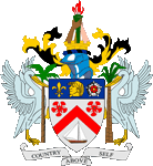
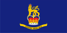
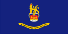
since 1967,
Coat of arms of Saint Kitts/Nevis,
Source, by: Corel Draw 4
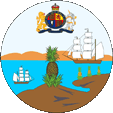
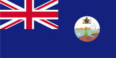
1871–1958,
Leeward Islands,
Badge (Emblem) of the Leeward Islands,
Source, by: Flags of the World
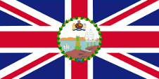
1958–1967,
Saint Christopher, Nevis and Anguilla,
Badge (Emblem) of Saint Christopher, Nevis and Anguilla,
Source, by: Flags of the World
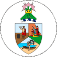
The coat of arms of Saint Kitts and Nevis was introduced on 16th of February in 1967. The shield shows in a blue upper part a lily, the head of a Carib woman and a Tudor rose. This embodies the history of the islands, which have been disputed between Britain and France in the past. In the middle part of the shield, on a silvery background, are two red poinciana flowers, a sailing ship and a red angle (chevron) between them. Supporters are two pelicans. Above the shield is a helmet with golden-black mantling, a black-blue torse and a torch held by three different colored human arms – a symbol of the three races on the islands. The motto in the silvery banner was originally "Unity and Trinity". This was changed to "Country above self" on the occasion of independence, as was the ship, which since 1983 has only one mast instead of two. The badge of the Leeward Islands, which included
Saint Christopher (Saint Kitts), Nevis and Anguilla between 1871 and 1958, showed a pineapple on a coast with two ships.
Saint Christopher (Saint Kitts), Nevis and Anguilla had already been administratively united into one colony within the colony of the Leeward Islands in 1882: Colony of
Saint Christopher (Saint Kitts), Nevis and Anguilla. The individual islands were probably already using their own seals, the images of which were combined on a heraldic shield in 1958 when the colony of the Leeward Islands was dissolved and the colony of
Saint Christopher (Saint Kitts), Nevis and Anguilla were allowed to use their own official emblems. This heraldic shield became the colony's badge on a white disc, used on a "Blue Ensign". The escutcheon was divided into three parts and showed the heraldic images of the individual islands: Columbus with a telescope on board of a ship (Saint
Kitts), three virgins at a spring (Nevis) and a native with his boat on a coast (Anguilla).
Source: Die Welt der Flaggen,
Flaggen Wappen Hymnen,
Flags of the World,
Wikipedia (EN),
Volker Preuß
Location:
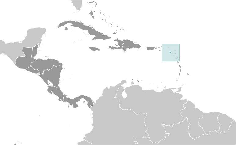
Source: CIA World Factbook
Map of the country:
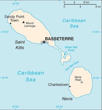
Source: CIA World Factbook
Area: 101 square miles, thereof Saint Kitts: 65 sq.mi., Nevis: 36 sq.mi.
Inhabitants: 53.000 (2020), thereof 90% Africans, 5,0% Mulattos, 3,0% Asians, 1,0% Europeans (British and Portugese)
Religions: 41% Protestant, 36% Anglican, 12% Roman Catholic
Density of Population: 78 inh./sq.mi.
Capital: Basseterre, 14.000 inh. (2021)
official Language: English
other Languages: Creole Dialects
Currency: Eastern Caribbean Dollar (XCD, EC-$) = 100 Cents
Time Zone: GMT – 4 h
Source:
Wikipedia (D)
Nevis:
Area: 36 sq.mi.
Inhabitants: 11.500
Density of Population: 48 inh./sq.mi.
Capital: Charlestown, 1.700 inh.
Source:
Wikipedia (D)
1493 · the Spanish seafarer Christoph Columbus discovers the islands and names them San Cristóbal (Saint
Christopherus, today shortend to "Saint Kitts") and Santa María de las Nieves, the islands become a Spanish possession but were not colonized
1620 · appropriation of Nevis by England
1623 · settlement of Saint Kitts by Englishmen
1625 · settlement of Saint Kitts by Frenchmen
1627–1666 · Saint Kitts is divided between England and France
1628 · settlement of Nevis by Englishmen from Saint Kitts
1666–1671 · Saint Kitts is French possession
1671–1689 · Saint Kitts is divided between England and France, the British possession becomes affiliated to the Leeward Islands Colony
1689–1690 · Saint Kitts is French possession
1690 · Saint Kitts becomes British possession and affiliated to the Leeward Islands Colony again
1706 · transitional French occupation
1713 · Treaty of Utrecht, United Kingdom earns Saint Kitts officially
1782–1783 · transitional French occupation
1816 · the Leeward Islands Colony becomes dissolved, Saint Kitts becomes fused with Anguilla, Nevis and the Virgin Islands
1833 · re-estbalishment of the Leeward Islands Colony, to 1958 part of the British Leeward Islands Colony
1882 · the British possessions of Saint Kitts, Nevis and Anguilla become fused within the Leeward Islands Colony (Colony of Saint Kitts, Nevis and Anguilla)
1958–1962 · part of the British colony "Federation of the West Indies"
27th of February 1967 · United Kingdom grants interior self administration (autonomy as with
United Kingdom associated state)
1969 · demands for independence on Anguilla
1971 · Anguilla becomes subordinated under the British administration again
1980 · Anguilla becomes separated from Saint Kitts/Nevis and becomes a self-contained colony
19th of September 1983 · United Kingdom grants independence within the framework of the Commonwealth of Nations, but Nevis gets a limited self administration
13th of October 1997 · the parliament of Nevis proclaims the independence of the island, not recognized
10th of August 1998 · a plebiscite on Nevis for independence fails
Source:
Atlas zur Geschichte,
World Statesmen,
Wikipedia (EN)
As columbus in 1493 discovered the today’s island of Saint Kitts, he named it San Cristóbal (by other sources Isla de San Jorge). The name
Saint Christopher is todays only shortend in use: "Saint Kitts".
As Columbus in 1493 discovered the today’s island of Nevis, he named it Santa María de las Nieves (Saint Maria of Snow), because he thought that the clouds on the volcano Nevis Peak are snow. Through the times became "Nieves" finally to "Nevis".
The Kalinago, the pre-European inhabitants of Saint Kitts, called the island "Liamuiga", which means "fertile land."
Source: Wikipedia (EN)