zur deutschen Version, Flagge klicken oder tippen

- Republica del Sexto Estado de los Altos
- 1838–1840, 1848
• Flag
• Meaning/Origin of the Flag
• Numbers and Facts
• History
• Origin of the Country's Name

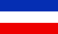
National flag,
ratio = 2:3,
Source, by: Flags of the World


Los Altos was a member of the Centalamerican Federation, and used its own flag. It showed three horizontal stripes in blue, white and blue.
Source:
Flags of the World, Volker Preuss

Area: ca. 10.800 square miles, roughly the present provinces: Huehuetenango, San Marcos, Quiché, Totonicapán, Sololá, Quetzaltenango, Retalhuleu, Suchitepéquez
Inhabitants: unknown
Capital: Quetzaltenango
official Language: Spanish
Currency: unknown
Time Zone: GMT – 6 h
Source:
Wikipedia (DE)

13th of January in 1838 · José Rafael Carrera Turcios conqueres Guatemala City and takes over in the Republic of Guatemala
2nd of February in 1838 · the southwestern provinces of Guatemala separate as "Republica del Sexto Estado de los Altos" from Guatemala and join the Central American Confederation
January 1840 · José Rafael Carrera Turcios reoccupies Los Altos and affiliates it back to Guatemala
1848 · Los Altos is again independent for a short time
Source: Wikipedia (D)

"Republica del Sexto Estado de los Altos" means translated: "Republic of the Sixth State of the Highlands". With the 'Sixth State' Los Altos is meant as the sixth member of the Central American Confederation.
Source: Volker Preuss


![]()


